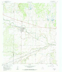
1960 Map of Melvin
USGS Topo · Published 1961About this map
The town of Melvin serves as the focal point of this Central Texas landscape, situated at the intersection of local commerce and the Gulf Colorado and Santa Fe railroad. The 1960 survey illustrates a region shaped by its hydrology, where Brady Creek and South Brady Creek wind through the terrain beneath the northern elevations of the Brady Mountains. This era shows a community supported by small-scale industrial activity, evidenced by several Gravel Pits and the proximity of the rail line which connects Melvin to Whiteland and Homer Junction to the east. Local history is anchored at the Melvin Cem and the small settlement of Lightner in the southwest corner. The map also records the implementation of water management in the Edwards Plateau region, identifying specifically numbered reservoirs like Reservoir No 41 and Reservoir No 39 designed to control drainage along the creek beds.
Find a feature on this map
25 named features on this map. Tap any name to fly to it.
Don’t see what you’re looking for? This feature index may not catch every label — zoom into the map to look around manually.
Map Details
Editions of this 1960 Melvin Map
2 editions found
Other maps of this area

1892 · Eden
USGS Topo · 1:125,000

1894 · Brady
USGS Topo · 1:125,000

1896 · Eden
USGS Topo · 1:125,000

1928 · Waldrip
USGS Topo · 1:62,500

1931 · Stacy
USGS Topo · 1:62,500

1954 · Brownwood
USGS Topo · 1:250,000

1960 · West Sweden
USGS Topo · 1:24,000

1960 · Melvin
USGS Topo · 1:24,000

1963 · Brady SW
USGS Topo · 1:24,000
1967 · Salt Gap
USGS Topo · 1:24,000