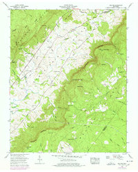
1956 Map of Melvine
USGS Topo · Published 1978About this map
The Sequatchie Valley and the steep Cumberland Escarpment define the geography of this mid-century survey, centered on the settlement of Melvine. The Sequatchie River winds through the valley floor, passing Ninemile and crossing below the Alvin C York Highway. High above the valley on the Cumberland Plateau Divide, landforms like Walker Knob and Worthington Knob provide strategic overlooks, the latter noted for its lookout tower.
Find a feature on this map
81 named features on this map. Tap any name to fly to it.
Don’t see what you’re looking for? This feature index may not catch every label — zoom into the map to look around manually.
Map Details
Editions of this 1956 Melvine Map
3 editions found
Other maps of this area

1887 · Kingston
USGS Topo · 1:125,000

1891 · Kingston
USGS Topo · 1:125,000

1892 · Pikeville
USGS Topo · 1:125,000

1893 · Kingston
USGS Topo · 1:125,000

1895 · Pikeville
USGS Topo · 1:125,000

1909 · Sequatchie Valley
USGS Topo · 1:62,500

1910 · Pikeville
USGS Topo · 1:62,500

1912 · Crossville
USGS Topo · 1:62,500

1935 · Melvine
USGS Topo · 1:24,000

1935 · Morgan Springs
USGS Topo · 1:24,000