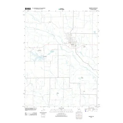
2012 Map of Memphis
USGS Topo · Published 2012About this map
The Memphis community serves as the central hub of this Northeast Missouri landscape, where the North Fabius River and several of its tributaries, including Gunns Branch and Pony Creek, carve a winding path through the terrain. The town's grid is surrounded by smaller settlements like Nauvoo and essential local infrastructure such as the Memphis Memorial Airport. The map highlights a significant emphasis on water management and recreation for the county, evidenced by the Memphis Lake and Park Dam and the nearby Memphis Reservoir.
Find a feature on this map
36 named features on this map. Tap any name to fly to it.
Don’t see what you’re looking for? This feature index may not catch every label — zoom into the map to look around manually.
Map Details
Editions of this 2012 Memphis Map
This is the sole edition of this map. No revisions or reprints were ever made.
Other maps of this area

1903 · Edina
USGS Topo · 1:125,000

1954 · Centerville
USGS Topo · 1:250,000

1957 · Centerville
USGS Topo · 1:250,000

1958 · Centerville
USGS Topo · 1:250,000

1965 · Memphis
USGS Topo · 1:24,000
1965 · Rutledge
USGS Topo · 1:24,000
1965 · Arbela
USGS Topo · 1:24,000

1965 · Greensburg
USGS Topo · 1:24,000

1966 · Downing
USGS Topo · 1:24,000
1966 · Bible Grove
USGS Topo · 1:24,000