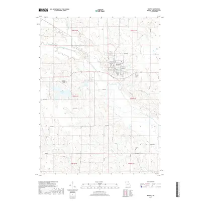
2017 Map of Memphis
USGS Topo · Published 2017About this map
Memphis serves as the seat of Scotland County, oriented around a classic Midwestern grid with primary thoroughfares like W Monroe St and S Main St. The surrounding landscape is defined by the winding course of the North Fabius River and its various tributaries including Indian Cr and Pony Cr. This 2017 survey illustrates the area's rural character and water management, featuring both the Memphis Reservoir and Memphis Lake, the latter located near the Memphis Memorial Airport. Local genealogy is well-supported by the inclusion of several burial grounds, such as Clark Cem to the north and Concord Cem and Antioch Cem to the south, which remain as key landmarks in the township sections. Small-scale water features like Kerrs Pond and Gunns Br further distinguish the terrain of Northeast Missouri.
Find a feature on this map
66 named features on this map. Tap any name to fly to it.
Don’t see what you’re looking for? This feature index may not catch every label — zoom into the map to look around manually.
Map Details
Editions of this 2017 Memphis Map
This is the sole edition of this map. No revisions or reprints were ever made.
Other maps of this area

1903 · Edina
USGS Topo · 1:125,000

1954 · Centerville
USGS Topo · 1:250,000

1957 · Centerville
USGS Topo · 1:250,000

1958 · Centerville
USGS Topo · 1:250,000

1965 · Memphis
USGS Topo · 1:24,000
1965 · Rutledge
USGS Topo · 1:24,000
1965 · Arbela
USGS Topo · 1:24,000

1965 · Greensburg
USGS Topo · 1:24,000

1966 · Downing
USGS Topo · 1:24,000
1966 · Bible Grove
USGS Topo · 1:24,000