
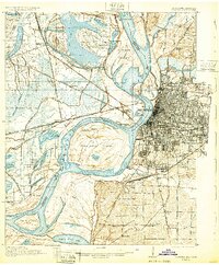
1927 Map of Memphis
USGS Topo · Published 1927About this map
Presidents Island dominates the bend of the Mississippi River in this survey, showcasing a landscape defined by the shifting waters of the Tennessee Chute and the Wolf River. The city of Memphis is shown at a pivotal moment of industrial and rail expansion, with the Illinois Central RR and Missouri Pacific RR converging near Bridge Junction. This rail density highlights the region's role as a primary logistics hub where the Arkansas and Tennessee borders meet. On the Arkansas side, rural life is marked by small settlements like Mound City and Wyanoke, alongside social centers such as Lake Grove Church and the Wyanoke School. The presence of Bunker Hill cemetery and Plunkett Chapel provides valuable touchstones for genealogists tracing family histories in the river bottomlands before mid-century development altered the terrain.
Find a feature on this map
96 named features on this map. Tap any name to fly to it.
Don’t see what you’re looking for? This feature index may not catch every label — zoom into the map to look around manually.
Map Details
Editions of this 1927 Memphis Map
2 editions found
Other maps of this area

1908 · Lake Cormorant
USGS Topo · 1:24,000

1912 · Lake Cormorant
USGS Topo · 1:31,680

1916 · Memphis
USGS Topo · 1:62,500

1925 · Memphis
USGS Topo · 1:48,000

1931 · Horseshoe Lake
USGS Topo · 1:62,500

1931 · Jericho
USGS Topo · 1:62,500

1932 · Horn Lake
USGS Topo · 1:48,000

1935 · Horn Lake
USGS Topo · 1:62,500

1939 · Horseshoe Lake
USGS Topo · 1:62,500

1939 · Jericho
USGS Topo · 1:62,500