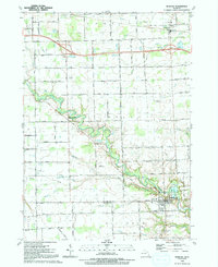
1991 Map of Memphis
USGS Topo · Published 1991About this map
The Belle River winds through the heart of this landscape, marking the boundary between St Clair Co and Macomb Co. At the southern edge, the village of Memphis serves as a local hub, characterized by a grid of streets and key landmarks such as the Memphis Cem and All Saints Ch. The surrounding countryside is defined by agricultural fields and a dense network of water management features, including the Tallmadge Drain, Bordman Drain, and Sumner Drain.
Find a feature on this map
68 named features on this map. Tap any name to fly to it.
Don’t see what you’re looking for? This feature index may not catch every label — zoom into the map to look around manually.
Map Details
Editions of this 1991 Memphis Map
This is the sole edition of this map. No revisions or reprints were ever made.
Other maps of this area

1914 · Armada
USGS Topo · 1:62,500

1928 · Armada
USGS Topo · 1:62,500

1928 · Hicky
USGS Topo · 1:62,500

1939 · Adair
USGS Topo · 1:24,000

1939 · Goodells
USGS Topo · 1:24,000

1944 · Memphis
USGS Topo · 1:24,000

1945 · Armada
USGS Topo · 1:24,000

1945 · Allenton
USGS Topo · 1:24,000

1945 · Richmond
USGS Topo · 1:24,000

1952 · Allenton
USGS Topo · 1:24,000