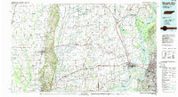
1986 Map of Memphis West
USGS Topo · Published 1989About this map
Crowleys Ridge rises above the alluvial plains of the Mississippi Delta in this 1980s landscape, providing a distinct geological divide between the western Arkansas lowlands and the riverfront. The map shows the dense transit corridors of Interstate 40 and Interstate 55 converging at West Memphis, a regional hub defined by its proximity to the Tennessee state line and the industrial activity on Presidents Island. Beyond the urban centers, the terrain is a complex network of drainage canals like Ditch No 6 and Ditch No 20, which reflect the extensive land reclamation required for agriculture in the Arkansas Delta. Protected lands such as Wapanocca National Wildlife Refuge and Village Creek State Park preserve pockets of natural bottomland and upland forest amidst a grid of rural settlements including Parkin, Earle, and Forrest City.
Find a feature on this map
225 named features on this map. Tap any name to fly to it.
Don’t see what you’re looking for? This feature index may not catch every label — zoom into the map to look around manually.
Map Details
Editions of this 1986 Memphis West Map
2 editions found
Other maps of this area

1908 · Lake Cormorant
USGS Topo · 1:24,000

1912 · Lake Cormorant
USGS Topo · 1:31,680

1916 · Memphis
USGS Topo · 1:62,500

1925 · Memphis
USGS Topo · 1:48,000

1927 · Memphis
USGS Topo · 1:62,500

1931 · Horseshoe Lake
USGS Topo · 1:62,500

1931 · Jericho
USGS Topo · 1:62,500

1932 · Horn Lake
USGS Topo · 1:48,000

1935 · Horn Lake
USGS Topo · 1:62,500

1935 · Tuckerman
USGS Topo · 1:62,500