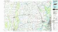
1986 Map of Memphis West
USGS Topo · Published 1986About this map
Crowleys Ridge rises above the alluvial plains of the Mississippi River delta, anchoring the western portion of this 1986 survey. The terrain transitions from the elevated forests of Village Creek State Park down toward the complex hydraulic network of the St Francis River and L'Anguille River. The landscape is defined by the tension between the river's natural meandering and the engineered infrastructure required to manage it, visible in the intricate system of bayous and floodplains surrounding Wapanocca National Wildlife Refuge.
Find a feature on this map
61 named features on this map. Tap any name to fly to it.
Don’t see what you’re looking for? This feature index may not catch every label — zoom into the map to look around manually.
Map Details
Editions of this 1986 Memphis West Map
2 editions found
Other maps of this area

1908 · Lake Cormorant
USGS Topo · 1:24,000

1912 · Lake Cormorant
USGS Topo · 1:31,680

1916 · Memphis
USGS Topo · 1:62,500

1925 · Memphis
USGS Topo · 1:48,000

1927 · Memphis
USGS Topo · 1:62,500

1931 · Horseshoe Lake
USGS Topo · 1:62,500

1931 · Jericho
USGS Topo · 1:62,500

1932 · Horn Lake
USGS Topo · 1:48,000

1935 · Horn Lake
USGS Topo · 1:62,500

1935 · Tuckerman
USGS Topo · 1:62,500