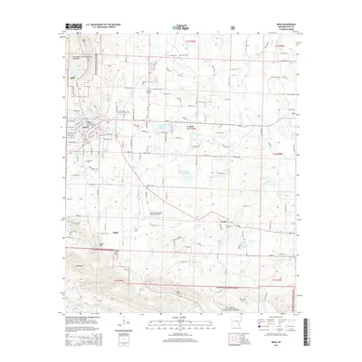
2014 Map of Mena
USGS Topo · Published 2014About this map
Mena serves as the central hub of this Polk County landscape, situated at the edge of the Ouachita National Forest. The topography is defined by the high ridges of Rich Mountain and Dallas Mountain, which rise sharply above the settlement. The town's connectivity is highlighted by the Mena Intermountain Municipal Airport and its proximity to the Rich Mountain Community College. Outside the city center, rural life is marked by small communities like Corinth and Nunley, each anchored by local landmarks such as the Corinth Cemetery and Nunley Cemetery. Drainage for the region is provided by the Ouachita River and a network of creeks including Prairie Creek and Brier Creek. This map illustrates the intersection of a established mountain town with the sprawling timberlands of the national forest, showing the proximity of early settlements like Dallas to modern infrastructure.
Find a feature on this map
57 named features on this map. Tap any name to fly to it.
Don’t see what you’re looking for? This feature index may not catch every label — zoom into the map to look around manually.
Map Details
Editions of this 2014 Mena Map
This is the sole edition of this map. No revisions or reprints were ever made.
Other maps of this area

1890 · Poteau Mountain
USGS Topo · 1:125,000

1899 · Poteau Mountain
USGS Topo · 1:125,000

1913 · De Queen
USGS Topo · 1:125,000

1950 · Mcalester
USGS Topo · 1:250,000
1958 · Board Camp
USGS Topo · 1:24,000

1958 · Mena
USGS Topo · 1:62,500

1958 · Potter
USGS Topo · 1:62,500

1958 · Mena
USGS Topo · 1:24,000
1958 · Y City
USGS Topo · 1:24,000

1958 · Rich Mountain
USGS Topo · 1:24,000