1967 Map of Mench
USGS Topo · Published 1970About this map
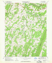
The Raystown Branch Juniata River meanders across the northern reaches of this rural Pennsylvania landscape, passing the site of Juniata Crossing and the industrial infrastructure at Jackson Mills. The terrain is defined by a succession of prominent ridges, including Polish Mountain, Clear Ridge, and Rays Hill, which dictate the local settlement and transportation patterns. Small communities like Mench and Mattie serve as focal points for the surrounding agricultural and wooded areas.
Find a feature on this map
38 named features on this map. Tap any name to fly to it.
Don’t see what you’re looking for? This feature index may not catch every label — zoom into the map to look around manually.
Map Details
Editions of this 1967 Mench Map
3 editions found
Historical Maps of West Providence Township Through Time
32 maps found

1908 Bedford
Bedford County, PA

1910 Bedford
Bedford County, PA

1927 Clearville
Bedford County, PA

1931 Clearville
Bedford County, PA

1944 Clearville
Bedford County, PA

1950 Artemas
Bedford County, PA

1967 Beans Cove
Bedford County, PA

1967 Buffalo Mills
Bedford County, PA

1967 Clearville
Bedford County, PA

1967 Mench
Bedford County, PA

1968 Chaneysville
Bedford County, PA

1968 Everett East
Bedford County, PA

1968 Everett West
Bedford County, PA

1968 New Enterprise
Bedford County, PA

1971 Alum Bank
Bedford County, PA

1971 Bedford
Bedford County, PA

1971 Ogletown
Bedford County, PA

1977 Ogletown
Bedford County, PA

1994 Everett East
Bedford County, PA

1994 Mench
Bedford County, PA

2023 Alum Bank
Bedford County, PA

2023 Artemas
Bedford County, PA

2023 Beans Cove
Bedford County, PA

2023 Bedford
Bedford County, PA

2023 Buffalo Mills
Bedford County, PA

2023 Chaneysville
Bedford County, PA

2023 Clearville
Bedford County, PA

2023 Everett East
Bedford County, PA

2023 Everett West
Bedford County, PA

2023 Mench
Bedford County, PA

2023 New Enterprise
Bedford County, PA

2023 Ogletown
Bedford County, PA
Featured Locations
- East Providence Township, PA
- West Providence Township, PA
- Brush Creek Township, PA
- Mattie, East Providence Township
- Clear Ridge, West Providence Township