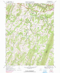
1967 Map of Mench
USGS Topo · Published 1990About this map
Raystown Branch Juniata River meanders through the northern portion of this quadrangle, creating a series of sharp bends and deep valleys that defined the early settlement patterns of Bedford and Fulton counties. The village of Mench sits atop the high ground of Clear Ridge, while Mattie serves as a small hub further south. The landscape is dominated by a succession of steep, parallel ridges including Polish Mountain, Raccoon Ridge, and the prominent Sideling Hill.
Find a feature on this map
39 named features on this map. Tap any name to fly to it.
Don’t see what you’re looking for? This feature index may not catch every label — zoom into the map to look around manually.
Map Details
Editions of this 1967 Mench Map
3 editions found
Other maps of this area

1900 · Everett
USGS Topo · 1:62,500

1902 · Everett
USGS Topo · 1:62,500

1925 · Needmore
USGS Topo · 1:48,000

1927 · Clearville
USGS Topo · 1:48,000

1930 · Broad Top
USGS Topo · 1:62,500

1931 · Clearville
USGS Topo · 1:62,500

1933 · Broad Top
USGS Topo · 1:62,500

1935 · Needmore
USGS Topo · 1:62,500

1939 · Needmore
USGS Topo · 1:62,500

1944 · Clearville
USGS Topo · 1:62,500
Featured Places
- West Providence Township, PA
- East Providence Township, PA
- Brush Creek Township, PA
- Clear Ridge, West Providence Township
- Mattie, East Providence Township