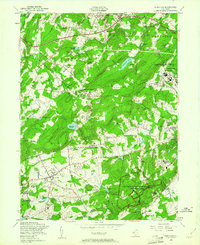
1954 Map of Mendham
USGS Topo · Published 1961About this map
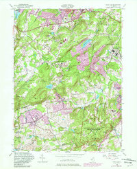
Morristown National Historical Park anchors the southern portion of this Morris County landscape, preserving the terrain where Revolutionary War troops wintered. The mid-century map reveals a concentration of institutional and religious properties, from the massive Greystone Park State Hospital in the northeast to the numerous convents and private academies such as Delbarton Sch and the Sisters of the Good Shepherd Convent. Between the growing boroughs of Mendham and Dover, the township of Randolph displays a mix of emerging suburban residential pockets and larger holdings like the Mortimer L Schiff Boy Scout Reservation. Water resources are central to the area's development, evidenced by the Clyde Potts Reservoir and Shongum Lake, which provided both utility and recreation for the surrounding communities during this period of post-war expansion.
Find a feature on this map
78 named features on this map. Tap any name to fly to it.
Don’t see what you’re looking for? This feature index may not catch every label — zoom into the map to look around manually.
Map Details
Editions of this 1954 Mendham Map
5 editions found
Other maps of this area

1888 · Plainfield
USGS Topo · 1:62,500

1888 · Morristown
USGS Topo · 1:62,500

1888 · Lake Hopatcong
USGS Topo · 1:62,500

1891 · Somerville
USGS Topo · 1:62,500

1893 · Plainfield
USGS Topo · 1:62,500

1893 · Somerville
USGS Topo · 1:62,500

1894 · Morristown
USGS Topo · 1:62,500

1894 · Lake Hopatcong
USGS Topo · 1:62,500

1898 · Lake Hopatcong
USGS Topo · 1:62,500

1898 · Morristown
USGS Topo · 1:62,500