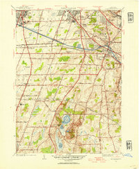
1952 Map of Mendon Ponds
USGS Topo · Published 1954About this map
The Barge Canal and several major rail lines, including the Lehigh Valley Railroad and the Erie Railroad, define the industrial and transit corridor south of Rochester. This mid-century survey captures a landscape in transition, where established institutions like the State Hospital and the Iola Sanitarium sit near emerging educational centers such as St John Fisher College and the Nazareth Convent and Normal School. To the south, the terrain becomes distinctively glacial around Hundred Acre Pond, featuring the uniquely named Devils Bathtub. A significant modern detail is the State Thruway (Under Construction), carving a path through the townships of Henrietta and Pittsford. This document records the shift from rural Monroe County to an integrated suburban and infrastructure network, evidenced by the cluster of transmission towers including Radio Sta Whec and Radio Sta Wsay.
Find a feature on this map
63 named features on this map. Tap any name to fly to it.
Don’t see what you’re looking for? This feature index may not catch every label — zoom into the map to look around manually.
Map Details
Editions of this 1952 Mendon Ponds Map
Other maps of this area

1895 · Rochester
USGS Topo · 1:62,500

1898 · Rochester
USGS Topo · 1:62,500

1900 · Macedon
USGS Topo · 1:62,500

1900 · Canandaigua
USGS Topo · 1:62,500

1901 · Honeoye
USGS Topo · 1:62,500

1903 · Canandaigua
USGS Topo · 1:62,500

1904 · Honeoye
USGS Topo · 1:62,500

1912 · Rochester
USGS Topo · 1:62,500

1920 · Rochester
USGS Topo · 1:62,500

1931 · Mendon Ponds
USGS Topo · 1:24,000