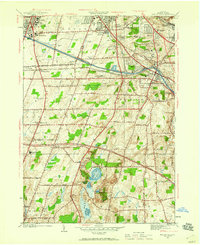
1952 Map of Mendon Ponds
USGS Topo · Published 1959About this map
The Barge Canal and West Shore Canal define the industrial and transport corridor south of Rochester, where infrastructure like the State Hospital, Iola Sanitarium, and the Monroe Co Home and Infirmary cluster near West Brighton. This mid-century landscape shows the transition from the rail-heavy era of the Erie Railroad and New York Central to the growth of institutions like St John Fisher College and several prominent country clubs. To the south, the terrain shifts dramatically within Mendon Ponds Park, a glacial landscape featuring the Devils Bathtub and a chain of water bodies including Hundred Acre Pond and Quaker Pond. The map serves as a detailed record of the suburban and institutional expansion of Henrietta and Pittsford before the full onset of modern highway development, preserving the locations of rural landmarks like East Ch Cem and the Rush-Henrietta Sch.
Find a feature on this map
54 named features on this map. Tap any name to fly to it.
Don’t see what you’re looking for? This feature index may not catch every label — zoom into the map to look around manually.
Map Details
Editions of this 1952 Mendon Ponds Map
Other maps of this area

1895 · Rochester
USGS Topo · 1:62,500

1898 · Rochester
USGS Topo · 1:62,500

1900 · Macedon
USGS Topo · 1:62,500

1900 · Canandaigua
USGS Topo · 1:62,500

1901 · Honeoye
USGS Topo · 1:62,500

1903 · Canandaigua
USGS Topo · 1:62,500

1904 · Honeoye
USGS Topo · 1:62,500

1912 · Rochester
USGS Topo · 1:62,500

1920 · Rochester
USGS Topo · 1:62,500

1931 · Mendon Ponds
USGS Topo · 1:24,000