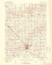
1952 Map of Mendota
USGS Topo · Published 1954About this map
The industrial and agricultural hub of Mendota sits at a critical junction of the Illinois Central and the Chicago Burlington and Quincy railroads in the early 1950s. This survey illustrates the intricate network of grain-hauling lines that supported local trade at settlements like Sublette, Triumph, and West Brooklyn. A significant cultural marker, the Indian Boundary line, cuts diagonally across the landscape south of town, reflecting early nineteenth-century land treaties. Genealogy researchers will find a wealth of specific data, including the Bauer Sch (Abandoned), the Abner Harding Cem, and several well-defined country churches such as Immanuel Ch and Clarion Ch. From the Third Principal Meridian to the scattered gravel pits and small water bodies like Lake Mendota, the map documents a transition from pioneer prairie to a highly organized rail and farming corridor.
Find a feature on this map
83 named features on this map. Tap any name to fly to it.
Don’t see what you’re looking for? This feature index may not catch every label — zoom into the map to look around manually.
Map Details
Editions of this 1952 Mendota Map
3 editions found

Other maps of this area

1892 · Ottawa
USGS Topo · 1:62,500

1893 · Hennepin
USGS Topo · 1:62,500

1893 · Lasalle
USGS Topo · 1:62,500

1909 · Hennepin
USGS Topo · 1:62,500

1911 · La Salle
USGS Topo · 1:62,500

1911 · Hennepin
USGS Topo · 1:62,500

1913 · La Salle
USGS Topo · 1:62,500

1915 · Ottawa
USGS Topo · 1:62,500

1918 · Dixon
USGS Topo · 1:62,500

1934 · De Kalb
USGS Topo · 1:62,500