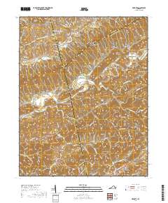
2019 Map of Mendota
USGS Topo · Published 2019About this map
Clinch Mountain forms a dramatic diagonal spine across this landscape, separating the northern Moccasin Valley from the parallel Poor Valley to the south. This terrain has historically dictated the settlement patterns of Southwest Virginia, concentrating communities like Mendota and Shelleys along the banks of the North Fork Holston River. The map reveals a dense network of family history markers, particularly through the numerous small cemeteries such as Garlin Smith Cem, Fleenor Cem, and Price Cem that dot the hollows. The presence of Barker Mill and the Free Hill Church underscores the agricultural and spiritual anchors of these valley communities. South of the river, the land rises again into Rich Valley and toward Dickey Mtn, where smaller water bodies like Abrams Creek carve through the deep ridgelines.
Find a feature on this map
116 named features on this map. Tap any name to fly to it.
Don’t see what you’re looking for? This feature index may not catch every label — zoom into the map to look around manually.
Map Details
Editions of this 2019 Mendota Map
This is the sole edition of this map. No revisions or reprints were ever made.
Other maps of this area

1897 · Bristol
USGS Topo · 1:125,000

1902 · Bristol
USGS Topo · 1:125,000

1918 · Carterton
USGS Topo · 1:62,500

1920 · Coeburn
USGS Topo · 1:48,000

1934 · Wallace
USGS Topo · 1:24,000

1934 · Hansonville
USGS Topo · 1:24,000

1934 · Bristol
USGS Topo · 1:24,000

1935 · Hilton
USGS Topo · 1:24,000

1935 · Mendota
USGS Topo · 1:24,000

1935 · Blountville
USGS Topo · 1:24,000