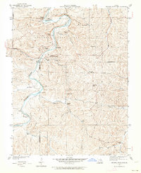
1934 Map of Meramec State Park
USGS Topo · Published 1964About this map
Meramec State Park serves as the focal point for this 1934 survey, capturing a landscape defined by the winding course of the Meramec River and the early infrastructure of Missouri's conservation efforts. The presence of a CCC Camp and the Lone Hill Firetower reflects the era's public works projects, while the surrounding terrain is marked by dozens of narrow drainage valleys such as Copper Hollow and Silver Hollow.
Find a feature on this map
47 named features on this map. Tap any name to fly to it.
Don’t see what you’re looking for? This feature index may not catch every label — zoom into the map to look around manually.
Map Details
Editions of this 1934 Meramec State Park Map
2 editions found
Other maps of this area

1901 · De Soto
USGS Topo · 1:125,000

1903 · Sullivan
USGS Topo · 1:125,000

1934 · Meramec State Park
USGS Topo · 1:24,000

1937 · Meramec State Park
USGS Topo · 1:24,000

1946 · Richwoods
USGS Topo · 1:62,500

1946 · Union
USGS Topo · 1:62,500

1947 · Sullivan
USGS Topo · 1:62,500

1947 · St. Clair
USGS Topo · 1:62,500

1948 · Richwoods
USGS Topo · 1:62,500

1948 · Union
USGS Topo · 1:62,500