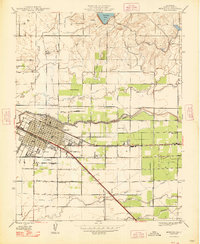
1948 Map of Merced
USGS Topo · Published 1948About this map
Merced serves as a thriving Central Valley hub in the late 1940s, anchored by the intersecting lines of the Atchison Topeka and Santa Fe and the Southern Pacific railroads. The town's layout is defined by institutional anchors such as Mercy Hospital, Merced General Hospital, and the local Fairgrounds. North of the city, the landscape transitions from the grid of Olive Avenue to the open Bear Creek Field and the waters of Yosemite Lake.
Find a feature on this map
34 named features on this map. Tap any name to fly to it.
Don’t see what you’re looking for? This feature index may not catch every label — zoom into the map to look around manually.
Map Details
Editions of this 1948 Merced Map
This is the sole edition of this map. No revisions or reprints were ever made.
Other maps of this area

1914 · Merced
USGS Topo · 1:31,680

1916 · Hopeton
USGS Topo · 1:31,680

1917 · Winton
USGS Topo · 1:31,680

1917 · Merced
USGS Topo · 1:31,680

1918 · Lingard
USGS Topo · 1:31,680

1918 · Atwater
USGS Topo · 1:31,680

1918 · Sandy Mush
USGS Topo · 1:31,680

1918 · Planada
USGS Topo · 1:31,680

1919 · Haystack Mountain
USGS Topo · 1:31,680

1919 · Plainsberg
USGS Topo · 1:31,680