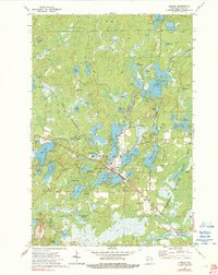
1973 Map of Mercer
USGS Topo · Published 1991About this map
Mercer sits at the heart of this Iron County landscape, positioned where the Chicago and North Western railway intersects a dense network of glacial lakes and river channels. The settlement pattern in the 1970s reflects a community deeply tied to the surrounding Northern Highland State Forest, with residential clusters gathered near Mercer Cem and Carow Park. The map reveals the intricate hydrography of the Turtle River system, which connects larger bodies like Pike Lake and Echo Lake.
Find a feature on this map
74 named features on this map. Tap any name to fly to it.
Don’t see what you’re looking for? This feature index may not catch every label — zoom into the map to look around manually.
Map Details
Editions of this 1973 Mercer Map
2 editions found
Other maps of this area

1939 · Winchester
USGS Topo · 1:48,000

1940 · Mercer
USGS Topo · 1:48,000

1943 · Ironwood
USGS Topo · 1:48,000

1945 · Mercer
USGS Topo · 1:48,000

1946 · Winchester
USGS Topo · 1:48,000

1947 · Mercer
USGS Topo · 1:48,000

1953 · Ashland
USGS Topo · 1:250,000

1955 · Mercer
USGS Topo · 1:62,500

1955 · Winchester
USGS Topo · 1:62,500

1955 · Wakefield
USGS Topo · 1:62,500