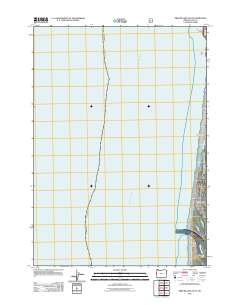
2011 Map of Mercer Lake OE W
USGS Topo · Published 2011About this map
Pacific Ocean swells dominate this coastal study, where the Oregon shoreline meets the water at the northern edge of the Siuslaw River mouth. The settlement at Heceta Beach sits just north of the river's entrance, illustrating the residential development pattern near the N Jetty Rd corridor. This particular section of the Lane County coast is defined by its distinct natural landmarks, ranging from the prominent Sea Lion Point and Cox Rock in the north to the sandy stretches of Baker Beach. The drainage of Sutton Creek cuts through the coastal dunes, while Cannery Point marks a historical industrial reference point along the lower Siuslaw River. The map provides a precise view of the interaction between the maritime environment and the emerging road network of the early 21st century.
Find a feature on this map
9 named features on this map. Tap any name to fly to it.
Don’t see what you’re looking for? This feature index may not catch every label — zoom into the map to look around manually.
Map Details
Editions of this 2011 Mercer Lake OE W Map
This is the sole edition of this map. No revisions or reprints were ever made.
Other maps of this area

1920 · Siltcoos Lake
USGS Topo · 1:62,500

1920 · Heceta Head
USGS Topo · 1:62,500

1941 · Siltcoos Lake
USGS Topo · 1:62,500

1942 · Heceta Head
USGS Topo · 1:62,500

1942 · Siltcoos Lake
USGS Topo · 1:62,500

1953 · Salem
USGS Topo · 1:250,000

1954 · Salem
USGS Topo · 1:250,000

1954 · Coos Bay
USGS Topo · 1:250,000
1956 · Heceta Head
USGS Topo · 1:62,500
1956 · Siltcoos Lake
USGS Topo · 1:62,500