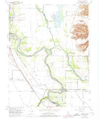
1952 Map of Meridian
USGS Topo · Published 1974About this map
The Sacramento River carves a winding path through this mid-century agricultural landscape, defining the border between Sutter and Colusa counties. Central to the area is the town of Meridian, situated along a sharp bend in the river and served by the Sacramento Northern Railroad. The topography is dominated by the dramatic rise of the Sutter Buttes to the east, while the low-lying Butte Sink and Colusa Basin illustrate the complex water management required in the valley. Extensive engineering is evident through the network of levees, the Colusa By-Pass, and the Colusa Weir. Smaller settlements like Arbee and Colusa appear alongside recreational landmarks such as the Butte Lodge Outing Club and Colusa's Shooting Club, highlighting the region's long-standing connection to waterfowl hunting and riparian land use.
Find a feature on this map
39 named features on this map. Tap any name to fly to it.
Don’t see what you’re looking for? This feature index may not catch every label — zoom into the map to look around manually.
Map Details
Editions of this 1952 Meridian Map
4 editions found
Other maps of this area

1888 · Marysville
USGS Topo · 1:125,000

1891 · Marysville
USGS Topo · 1:125,000

1894 · Marysville
USGS Topo · 1:125,000

1895 · Marysville
USGS Topo · 1:125,000

1906 · Maxwell
USGS Topo · 1:62,500

1907 · Colusa
USGS Topo · 1:62,500

1911 · Sanborn Slough
USGS Topo · 1:31,680

1911 · Grimes
USGS Topo · 1:31,680

1912 · Marysville Buttes
USGS Topo · 1:31,680

1912 · Pennington
USGS Topo · 1:31,680