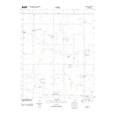
2010 Map of Meridian
USGS Topo · Published 2010About this map
Meridian and its surrounding rural landscapes are defined by an extensive network of small reservoirs and flood control dams along the upper reaches of the Bear Creek watershed. This 2010 survey details a complex system of managed waterways, including Bear Fall Coon Creek Site 17 Reservoir and several numbered sites that structure the local drainage. These water management features reflect the area's agricultural priorities and modern topographic engineering, contrasting with the much older human geography preserved in the region's many burial grounds. Genealogists will find a high concentration of cemeteries scattered across the township lines, from the Union Hill Cemetery in the north to the Iowa Mission Cemetery in the southeast. These sites, along with smaller plots like Favor Cemetery and Jordan Cemetery, provide a direct connection to the early families who settled this portion of Logan County. Small community centers such as Iconium, Merrick, and Shiloh remain as primary nodes within the grid-based road system.
Find a feature on this map
57 named features on this map. Tap any name to fly to it.
Don’t see what you’re looking for? This feature index may not catch every label — zoom into the map to look around manually.
Map Details
Editions of this 2010 Meridian Map
This is the sole edition of this map. No revisions or reprints were ever made.
Other maps of this area

1892 · Guthrie
USGS Topo · 1:62,500

1892 · Edmond
USGS Topo · 1:62,500

1909 · Luther
USGS Topo · 1:62,500

1909 · Perkins
USGS Topo · 1:62,500

1935 · Edmond
USGS Topo · 1:48,000

1940 · Edmond
USGS Topo · 1:62,500

1954 · Oklahoma City
USGS Topo · 1:250,000

1957 · Oklahoma City
USGS Topo · 1:250,000

1963 · Oklahoma City
USGS Topo · 1:250,000
1966 · Arcadia
USGS Topo · 1:24,000