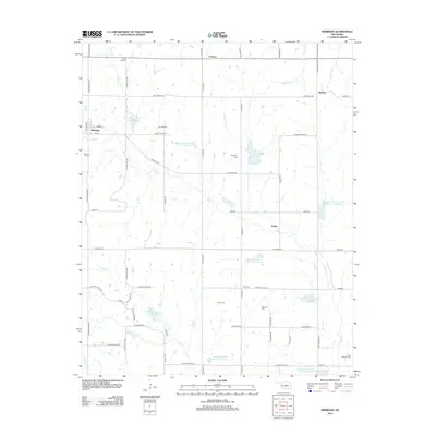
2012 Map of Meridian
USGS Topo · Published 2012About this map
The small community of Meridian serves as the focal point for this rural Oklahoma landscape, situated at the western edge of the Indian Meridian. The area is characterized by a high concentration of cemeteries including Union Hill Cem, Iowa Mission Cem, and McKinley Cem, providing significant geographic markers for genealogical research in Logan County. This 2012 survey illustrates a sophisticated watershed management system through the Bear Fall Coon Creek reservoir series, featuring sites like Bear Fall Coon Cr Site 7 Reservoir and Bear Fall Coon Cr Site 18 Reservoir. Smaller settlements such as Iconium, Merrick, and Shiloh are connected by a grid-iron road network of section lines, where S Indian Meridian and N Luther Rd traverse a terrain defined by the drainages of Bear Cr and Fall Cr.
Find a feature on this map
58 named features on this map. Tap any name to fly to it.
Don’t see what you’re looking for? This feature index may not catch every label — zoom into the map to look around manually.
Map Details
Editions of this 2012 Meridian Map
This is the sole edition of this map. No revisions or reprints were ever made.
Other maps of this area

1892 · Guthrie
USGS Topo · 1:62,500

1892 · Edmond
USGS Topo · 1:62,500

1909 · Luther
USGS Topo · 1:62,500

1909 · Perkins
USGS Topo · 1:62,500

1935 · Edmond
USGS Topo · 1:48,000

1940 · Edmond
USGS Topo · 1:62,500

1954 · Oklahoma City
USGS Topo · 1:250,000

1957 · Oklahoma City
USGS Topo · 1:250,000

1963 · Oklahoma City
USGS Topo · 1:250,000
1966 · Arcadia
USGS Topo · 1:24,000