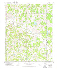
1978 Map of Meridian
USGS Topo · Published 1979About this map
Meridian stands at the western edge of this landscape, situated along the county line between Logan Co and Lincoln Co. In the late 1970s, the region retained a distinctly rural and scattered character, with small communities like Iconium and Merrick connected by a network of section roads and pipelines. The terrain is deeply carved by drainage systems, most notably Bear Creek and Walnut Creek, which flow toward the Cimarron River just off-sheet.
Find a feature on this map
25 named features on this map. Tap any name to fly to it.
Don’t see what you’re looking for? This feature index may not catch every label — zoom into the map to look around manually.
Map Details
Editions of this 1978 Meridian Map
This is the sole edition of this map. No revisions or reprints were ever made.
Other maps of this area

1892 · Guthrie
USGS Topo · 1:62,500

1892 · Edmond
USGS Topo · 1:62,500

1909 · Luther
USGS Topo · 1:62,500

1909 · Perkins
USGS Topo · 1:62,500

1935 · Edmond
USGS Topo · 1:48,000

1940 · Edmond
USGS Topo · 1:62,500

1954 · Oklahoma City
USGS Topo · 1:250,000

1957 · Oklahoma City
USGS Topo · 1:250,000

1963 · Oklahoma City
USGS Topo · 1:250,000
1966 · Arcadia
USGS Topo · 1:24,000