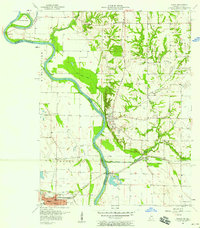
1957 Map of Merom
USGS Topo · Published 1958About this map
Merom sits prominently on the bluffs overlooking the winding Wabash River in this mid-century survey. The landscape is defined by the sharp divide between the elevated Indiana terrace and the broad, flat river bottomlands of Illinois to the west. This stretch of the river is marked by several significant fluvial features, including Eagle Island, Merom Island, and the Hutsonville Cutoff. The transition from river-based transport to rail and road is evident, with the Merom Ferry still indicated alongside the Illinois Central railroad and the Hutsonville Bridge.
Find a feature on this map
46 named features on this map. Tap any name to fly to it.
Don’t see what you’re looking for? This feature index may not catch every label — zoom into the map to look around manually.
Map Details
Editions of this 1957 Merom Map
This is the sole edition of this map. No revisions or reprints were ever made.
Other maps of this area

1917 · Birds
USGS Topo · 1:62,500

1942 · Fairbanks
USGS Topo · 1:24,000

1942 · Shelburn
USGS Topo · 1:24,000

1942 · Birds
USGS Topo · 1:62,500

1943 · Merom
USGS Topo · 1:24,000

1943 · Carlisle
USGS Topo · 1:24,000

1943 · Sullivan
USGS Topo · 1:24,000

1952 · Fairbanks
USGS Topo · 1:24,000

1952 · Shelburn
USGS Topo · 1:24,000

1953 · Indianapolis
USGS Topo · 1:250,000