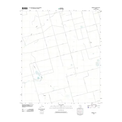
2010 Map of Merrick
USGS Topo · Published 2010About this map
Merrick stands as a focal point in this portion of Martin County, representing the scattered settlement patterns typical of the Texas High Plains in the early 21st century. The landscape is defined by an extensive grid of county roads and farm-to-market routes, including Farm Rd 2202-E and Farm Rd 26-N, which navigate the vast, open reaches of the Llano Estacado. Hydrological features are sparse but significant, centered on the winding path of Sulphur Springs Draw that cuts across the terrain. The presence of Dry Wells in the northeastern quadrant suggests the historical and ongoing challenges of water management and resource extraction in this arid environment. This survey captures a moment of transition where traditional ranching and farming infrastructure exists alongside more modern industrial markers, illustrated by the precise network of roads such as Co Rd 4400 and Co Rd 3800 that divide the land into large, functional blocks.
Find a feature on this map
25 named features on this map. Tap any name to fly to it.
Don’t see what you’re looking for? This feature index may not catch every label — zoom into the map to look around manually.
Map Details
Editions of this 2010 Merrick Map
This is the sole edition of this map. No revisions or reprints were ever made.
Other maps of this area

1954 · Big Spring
USGS Topo · 1:250,000

1958 · Big Spring
USGS Topo · 1:250,000

1966 · Knott
USGS Topo · 1:24,000

1966 · Merrick
USGS Topo · 1:24,000

1966 · Lenorah West
USGS Topo · 1:24,000

1966 · Flower Grove
USGS Topo · 1:24,000

1966 · Knott SW
USGS Topo · 1:24,000
1966 · Lenorah East
USGS Topo · 1:24,000

1970 · Ackerly
USGS Topo · 1:24,000
1970 · Tenmile
USGS Topo · 1:24,000