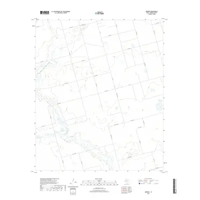
2019 Map of Merrick
USGS Topo · Published 2019About this map
Sulphur Springs Draw snakes across this West Texas landscape, defining the local hydrology in a region characterized by its expansive agricultural and ranching grid. Mapping by the U.S. Geological Survey reveals a high-density network of county roads, such as Co Rd 4400 and Co Rd 4100, which divide the terrain into large rectangular sections typical of the Permian Basin's rural development. The intersection of several farm-to-market routes, including N FM 26 and Farm Rd 3263-E, suggests a landscape organized for transit and resource management. The map's contour lines show the gradual elevation changes that direct intermittent water flow through the draw, illustrating the subtle but essential drainage patterns in Martin County.
Find a feature on this map
28 named features on this map. Tap any name to fly to it.
Don’t see what you’re looking for? This feature index may not catch every label — zoom into the map to look around manually.
Map Details
Editions of this 2019 Merrick Map
This is the sole edition of this map. No revisions or reprints were ever made.
Other maps of this area

1954 · Big Spring
USGS Topo · 1:250,000

1958 · Big Spring
USGS Topo · 1:250,000

1966 · Knott
USGS Topo · 1:24,000

1966 · Merrick
USGS Topo · 1:24,000

1966 · Lenorah West
USGS Topo · 1:24,000

1966 · Flower Grove
USGS Topo · 1:24,000

1966 · Knott SW
USGS Topo · 1:24,000
1966 · Lenorah East
USGS Topo · 1:24,000

1970 · Ackerly
USGS Topo · 1:24,000
1970 · Tenmile
USGS Topo · 1:24,000