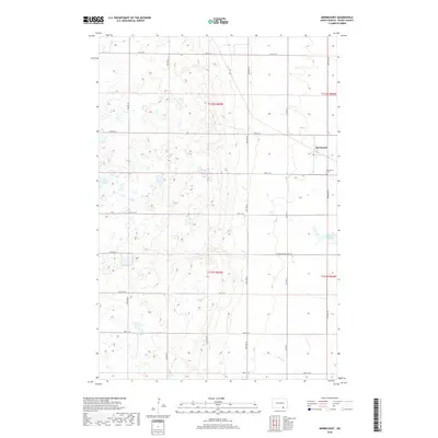
2018 Map of Merricourt
USGS Topo · Published 2018About this map
Merricourt serves as the primary focal point of this Dickey County landscape, where the prairie is defined by an extensive network of seasonal wetlands and glacial potholes. The settlement is supported by the Merricourt Cem to its southeast, reflecting the localized genealogy of this rural community. The terrain is marked by the passage of the Elm River, which meanders through the southern portion of the quadrangle, while Wilson Dam provides a significant water management point to the east. Transportation in this part of North Dakota is dictated by a strict section-line grid, exemplified by the Manango Merricourt Rd and numerous numbered avenues like 78th Ave SE. The survey captures the quiet, agricultural character of the region, where land use is dictated by the subtle elevation changes of the surrounding plains.
Find a feature on this map
22 named features on this map. Tap any name to fly to it.
Don’t see what you’re looking for? This feature index may not catch every label — zoom into the map to look around manually.
Map Details
Editions of this 2018 Merricourt Map
This is the sole edition of this map. No revisions or reprints were ever made.
Other maps of this area

1894 · Monango
USGS Topo · 1:62,500

1896 · Edgeley
USGS Topo · 1:125,000

1925 · Edgeley
USGS Topo · 1:125,000

1953 · Jamestown
USGS Topo · 1:250,000

1956 · Jamestown
USGS Topo · 1:250,000
1971 · Merricourt SE
USGS Topo · 1:24,000

1971 · Merricourt
USGS Topo · 1:24,000

1971 · Merricourt NW
USGS Topo · 1:24,000
1971 · Merricourt SW
USGS Topo · 1:24,000
1982 · Monango NW
USGS Topo · 1:24,000