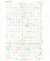
1971 Map of Merricourt SW
USGS Topo · Published 1973About this map
Wirch stands as a focal point in this 1971 survey of Dickey County, where the landscape is defined by the prairie potholes of the Missouri Coteau. The map reveals a rural community structure centered around localized landmarks like the Wirch Cemetery and a rural Townhall. This era in North Dakota's history is characterized by a high density of small, seasonal water bodies, including Wood Lake, Crow Lake, and the Crab Tree Lakes, which dot the terrain between established township divisions. The presence of numerous Gravel Pits suggests the ongoing importance of local material extraction for the region's road network, while the vast townships of Spring Valley and Albertha illustrate the organized agricultural grid. Notable modern infrastructure also appears, including Radio Towers positioned on the higher ground of the pothole region.
Find a feature on this map
19 named features on this map. Tap any name to fly to it.
Don’t see what you’re looking for? This feature index may not catch every label — zoom into the map to look around manually.
Map Details
Editions of this 1971 Merricourt SW Map
This is the sole edition of this map. No revisions or reprints were ever made.
Other maps of this area

1896 · Edgeley
USGS Topo · 1:125,000

1899 · Ellendale
USGS Topo · 1:125,000

1925 · Edgeley
USGS Topo · 1:125,000

1953 · Jamestown
USGS Topo · 1:250,000

1954 · Aberdeen
USGS Topo · 1:250,000

1956 · Aberdeen
USGS Topo · 1:250,000

1956 · Jamestown
USGS Topo · 1:250,000

1968 · Forbes
USGS Topo · 1:24,000

1968 · Long Lake NE
USGS Topo · 1:24,000
1968 · Forbes NW
USGS Topo · 1:24,000