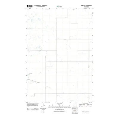
2011 Map of Merricourt SE
USGS Topo · Published 2011About this map
The northern Great Plains landscape of Dickey County is defined by its sectional grid and subtle drainage patterns. In this region, Rainbow Ranch stands as a primary named landmark among the section lines and rural thoroughfares like 90th St SE and 76th Ave SE. The terrain is marked by seasonal watercourses such as Bristol Gulch and Webber Gulch, which navigate the open prairie. In the southwest, water management is evident at Moores Lake, created by the construction of Moores Dam. This survey illustrates the persistent agricultural geometry of North Dakota, where the placement of roads and farmsteads follows the strict township and range system, providing a clear view of the area's modern rural infrastructure.
Find a feature on this map
18 named features on this map. Tap any name to fly to it.
Don’t see what you’re looking for? This feature index may not catch every label — zoom into the map to look around manually.
Map Details
Editions of this 2011 Merricourt SE Map
This is the sole edition of this map. No revisions or reprints were ever made.
Other maps of this area

1894 · Monango
USGS Topo · 1:62,500

1894 · Ellendale
USGS Topo · 1:62,500

1896 · Edgeley
USGS Topo · 1:125,000

1899 · Ellendale
USGS Topo · 1:125,000

1925 · Edgeley
USGS Topo · 1:125,000

1953 · Jamestown
USGS Topo · 1:250,000

1954 · Aberdeen
USGS Topo · 1:250,000

1956 · Aberdeen
USGS Topo · 1:250,000

1956 · Jamestown
USGS Topo · 1:250,000
1968 · Frederick NW
USGS Topo · 1:24,000
Featured Places
- Hamburg Township, ND
- Whitestone Township, ND
- Grand Valley Township, ND
- Albion Township, ND
- Lorraine Township, ND