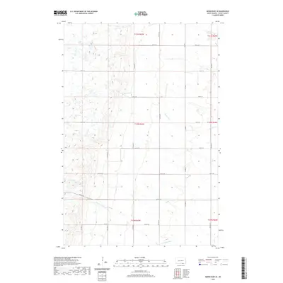
2020 Map of Merricourt SE
USGS Topo · Published 2020About this map
The rolling prairies of Dickey County are defined by their hydrological features in this recent topographic study of the region. Small, distinctive prairie potholes like Moores Lake and Happy Lake dot the western portion of the terrain, representing the characteristic glaciated landscape of the northern plains. These isolated water bodies are connected by a subtle network of intermittent drainages, including the eastern reach of the Elm River and the winding paths of Bristol Gulch and Webber Gulch. The township structure is clearly preserved by a grid of local roads such as 90th St SE and Co Hwy 2, which segment the landscape into traditional sections. This map captures the agricultural continuity of the area, showing how modern transportation routes like 96th St SE follow the historical section lines established during the early settlement era.
Find a feature on this map
28 named features on this map. Tap any name to fly to it.
Don’t see what you’re looking for? This feature index may not catch every label — zoom into the map to look around manually.
Map Details
Editions of this 2020 Merricourt SE Map
This is the sole edition of this map. No revisions or reprints were ever made.
Other maps of this area

1894 · Monango
USGS Topo · 1:62,500

1894 · Ellendale
USGS Topo · 1:62,500

1896 · Edgeley
USGS Topo · 1:125,000

1899 · Ellendale
USGS Topo · 1:125,000

1925 · Edgeley
USGS Topo · 1:125,000

1953 · Jamestown
USGS Topo · 1:250,000

1954 · Aberdeen
USGS Topo · 1:250,000

1956 · Aberdeen
USGS Topo · 1:250,000

1956 · Jamestown
USGS Topo · 1:250,000
1968 · Frederick NW
USGS Topo · 1:24,000
Featured Places
- Hamburg Township, ND
- Whitestone Township, ND
- Grand Valley Township, ND
- Albion Township, ND
- Lorraine Township, ND