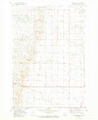
1971 Map of Merricourt SE
USGS Topo · Published 1973About this map
Whitestone Hill rises as a prominent landmark in this prairie landscape of Dickey County, overlooking the broad expanse of Grand Valley. The map, surveyed in the early 1970s, reveals a rural organization defined by localized civic centers and drainage features like Bristol Gulch and Albion Gulch. Settlement patterns are anchored by modest structures such as the Townhall located near the center of the sheet and a small Cem in the northeast, which alongside the Hamburg township line, provide essential points of reference for genealogists. The southwestern portion is dominated by the marshy edge of Happy Lake and the Lorraine township area, while scattered Gravel Pits indicate local resource extraction during this era. Fine red dashed lines throughout the quadrangle denote field and fence lines as seen from 1967 aerial photography, offering a detailed view of mid-century agricultural land division.
Find a feature on this map
11 named features on this map. Tap any name to fly to it.
Don’t see what you’re looking for? This feature index may not catch every label — zoom into the map to look around manually.
Map Details
Editions of this 1971 Merricourt SE Map
This is the sole edition of this map. No revisions or reprints were ever made.
Other maps of this area

1894 · Monango
USGS Topo · 1:62,500

1894 · Ellendale
USGS Topo · 1:62,500

1896 · Edgeley
USGS Topo · 1:125,000

1899 · Ellendale
USGS Topo · 1:125,000

1925 · Edgeley
USGS Topo · 1:125,000

1953 · Jamestown
USGS Topo · 1:250,000

1954 · Aberdeen
USGS Topo · 1:250,000

1956 · Aberdeen
USGS Topo · 1:250,000

1956 · Jamestown
USGS Topo · 1:250,000
1968 · Frederick NW
USGS Topo · 1:24,000
Featured Places
- Elm Township, ND
- Hamburg Township, ND
- Albion Township, ND
- Grand Valley Township, ND
- Whitestone Township, ND