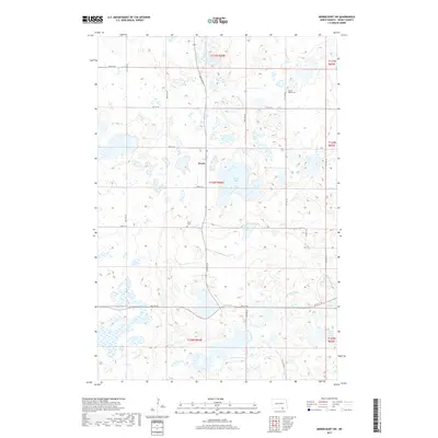
2017 Map of Merricourt SW
USGS Topo · Published 2017About this map
Wirch stands as a focal point in this portion of Dickey County, where the agricultural landscape of the Great Plains is defined by a high concentration of prairie potholes and small wetlands. The settlement is anchored by local heritage sites, including the Wirch Cem and the Spring Valley Cem to the northeast. The terrain is characterized by numerous water bodies that vary from the larger Wood Lake and Crow Lake to the scattered Crab Tree Lakes and the drainage of Webber Gulch. A precise grid of section-line roads, such as 96th St SE and 69th Ave SE, facilitates movement through this rural township structure. This survey documents the intersection of several townships, including t130n r66w and t129n r66w, capturing the persistent pattern of North Dakota's rural land division.
Find a feature on this map
26 named features on this map. Tap any name to fly to it.
Don’t see what you’re looking for? This feature index may not catch every label — zoom into the map to look around manually.
Map Details
Editions of this 2017 Merricourt SW Map
This is the sole edition of this map. No revisions or reprints were ever made.
Other maps of this area

1896 · Edgeley
USGS Topo · 1:125,000

1899 · Ellendale
USGS Topo · 1:125,000

1925 · Edgeley
USGS Topo · 1:125,000

1953 · Jamestown
USGS Topo · 1:250,000

1954 · Aberdeen
USGS Topo · 1:250,000

1956 · Aberdeen
USGS Topo · 1:250,000

1956 · Jamestown
USGS Topo · 1:250,000

1968 · Forbes
USGS Topo · 1:24,000

1968 · Long Lake NE
USGS Topo · 1:24,000
1968 · Forbes NW
USGS Topo · 1:24,000
Featured Places
- Wirch, ND
- Spring Valley Township, ND
- Whitestone Township, ND
- German Township, ND
- Grand Valley Township, ND