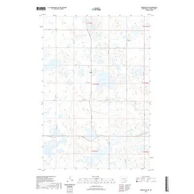
2020 Map of Merricourt SW
USGS Topo · Published 2020About this map
Wirch stands as a focal point in this section of Dickey County, a prairie landscape defined by its glacial potholes and scattered water bodies. The settlement's history is anchored by its nearby burial grounds, including Wirch Cem and Spring Valley Cem, which serve as vital markers for local genealogical research. The terrain is characterized by a series of significant basins including Wood Lake, Crow Lake, and Happy Lake, while the topographic relief of Webber Gulch cuts through the southeastern corner of the quadrangle. A rigorous grid of township roads, such as 96th St SE and 69th Ave SE, organizes the land into the traditional sections of the Public Land Survey System, illustrating the enduring agricultural structure of the North Dakota plains in the early 21st century.
Find a feature on this map
26 named features on this map. Tap any name to fly to it.
Don’t see what you’re looking for? This feature index may not catch every label — zoom into the map to look around manually.
Map Details
Editions of this 2020 Merricourt SW Map
This is the sole edition of this map. No revisions or reprints were ever made.
Other maps of this area

1896 · Edgeley
USGS Topo · 1:125,000

1899 · Ellendale
USGS Topo · 1:125,000

1925 · Edgeley
USGS Topo · 1:125,000

1953 · Jamestown
USGS Topo · 1:250,000

1954 · Aberdeen
USGS Topo · 1:250,000

1956 · Aberdeen
USGS Topo · 1:250,000

1956 · Jamestown
USGS Topo · 1:250,000

1968 · Forbes
USGS Topo · 1:24,000

1968 · Long Lake NE
USGS Topo · 1:24,000
1968 · Forbes NW
USGS Topo · 1:24,000
Featured Places
- Wirch, ND
- Spring Valley Township, ND
- Whitestone Township, ND
- German Township, ND
- Grand Valley Township, ND