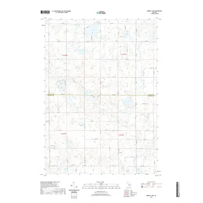
2019 Map of Merrill Lake
USGS Topo · Published 2019About this map
Merrill Lake and a dense network of kettle lakes characterize this portion of the Mecosta and Osceola county line in central Michigan. The landscape is defined by the headwaters and tributaries of the North Branch Chippewa River, which winds through the eastern half of the map. Traces of 19th-century settlement remain visible through several rural burial grounds, including Sparks Cem in the west and Brown Cem near the riverbanks. The grid-based road system, with primary arteries like Meceola Rd and 80th Ave, follows the township and range lines of the Public Land Survey System, dividing a territory rich in wetlands and small water bodies such as Rattail Lakes, McElwin Lake, and Bassen Lake. This late-2010s survey shows the continued integration of residential lanes like Timber Bend Rd and Lazy Acres Ln around the shorelines of Big Lake and Rice Lake, reflecting the area's development as a contemporary lakeside retreat.
Find a feature on this map
62 named features on this map. Tap any name to fly to it.
Don’t see what you’re looking for? This feature index may not catch every label — zoom into the map to look around manually.
Map Details
Editions of this 2019 Merrill Lake Map
This is the sole edition of this map. No revisions or reprints were ever made.
Other maps of this area

1954 · Midland
USGS Topo · 1:250,000

1958 · Midland
USGS Topo · 1:250,000

1958 · Big Rapids
USGS Topo · 1:62,500

1959 · Midland
USGS Topo · 1:250,000

1959 · Lake
USGS Topo · 1:62,500

1959 · Evart
USGS Topo · 1:62,500

1964 · Mecosta NW
USGS Topo · 1:24,000

1964 · Sherman City
USGS Topo · 1:24,000

1966 · Midland
USGS Topo · 1:250,000
1976 · Big Rapids NE
USGS Topo · 1:24,000