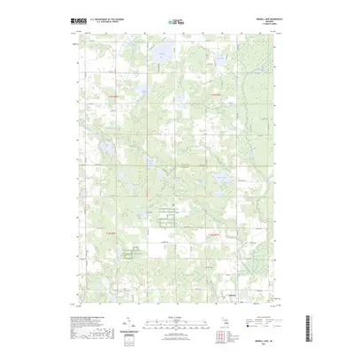
2023 Map of Merrill Lake
USGS Topo · Published 2023About this map
Barryton sits at the intersection of a sprawling lake-and-river network in Mecosta County, where the North Branch Chippewa River meanders through lowlands. This modern survey illustrates a landscape defined by glacial kettle lakes and structured by a rigid section-line road grid, featuring many named water bodies like Big Lake, Merrill Lake, and the connected Rattail Lakes. The drainage patterns are clearly visible as Browne Creek and Thorn Creek feed into the larger river system. Genealogists will find several burial grounds mapped across the township, including Sparks Cem, Brown Cem, and Eaton Cem, which serve as quiet markers of the area's rural development. Extensive tracts are marked as Farm Service Agency Interest of Michigan, indicating the ongoing role of state and federal land management in this agricultural and recreational region.
Find a feature on this map
42 named features on this map. Tap any name to fly to it.
Don’t see what you’re looking for? This feature index may not catch every label — zoom into the map to look around manually.
Map Details
Editions of this 2023 Merrill Lake Map
This is the sole edition of this map. No revisions or reprints were ever made.
Other maps of this area

1954 · Midland
USGS Topo · 1:250,000

1958 · Midland
USGS Topo · 1:250,000

1958 · Big Rapids
USGS Topo · 1:62,500

1959 · Midland
USGS Topo · 1:250,000

1959 · Lake
USGS Topo · 1:62,500

1959 · Evart
USGS Topo · 1:62,500

1964 · Mecosta NW
USGS Topo · 1:24,000

1964 · Sherman City
USGS Topo · 1:24,000

1966 · Midland
USGS Topo · 1:250,000
1976 · Big Rapids NE
USGS Topo · 1:24,000