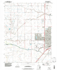
1992 Map of Merritt
USGS Topo · Published 1997About this map
Plainfield and Merritt sit at the heart of this agricultural and academic landscape in the early 1990s, defined by a complex network of irrigation and drainage. The Southern Pacific Railroad cuts through the territory, passing Elston Spur as it heads toward the expanding western edge of Davis. The map highlights the significant footprint of the University of California, which occupies a large portion of the southeastern corner, bordered by the South Fork Putah Creek and its protective Levee.
Find a feature on this map
24 named features on this map. Tap any name to fly to it.
Don’t see what you’re looking for? This feature index may not catch every label — zoom into the map to look around manually.
Map Details
Editions of this 1992 Merritt Map
This is the sole edition of this map. No revisions or reprints were ever made.
Other maps of this area

1907 · Woodland
USGS Topo · 1:62,500

1907 · Davisville
USGS Topo · 1:62,500

1908 · Vacaville
USGS Topo · 1:62,500

1908 · Courtland
USGS Topo · 1:62,500

1915 · Yolo
USGS Topo · 1:31,680

1915 · Swingle
USGS Topo · 1:31,680

1915 · Merritt
USGS Topo · 1:31,680

1916 · Dixon
USGS Topo · 1:31,680

1916 · Grays Bend
USGS Topo · 1:31,680

1916 · Jacobs Corner
USGS Topo · 1:31,680