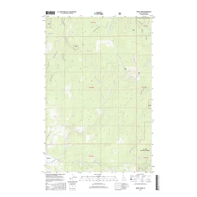
2017 Map of Merry Creek
USGS Topo · Published 2017About this map
Clarkia sits at the southwestern edge of this landscape, serving as a gateway to the dense timberlands and high ridges of the St. Joe National Forest. The terrain is defined by its complex drainage network, where the Middle Fork Saint Maries River is fed by a myriad of tributaries including Merry Creek and Lines Cr. High points like Swan Peak and Grandmother Mountain overlook a network of modern forest service roads and specialized off-highway vehicle routes such as the Blackwell OHV and Cranberry OHV. These trails often follow the divides between drainages, tracing the same ridges used for passage for generations. A unique notation for Lines Creek Historical suggests a change in the watercourse or a site of past significance, while the presence of The Incline and several named passes like Davies Pass and Hobo Pass points to the area's history of logging and resource extraction in Shoshone County.
Find a feature on this map
50 named features on this map. Tap any name to fly to it.
Don’t see what you’re looking for? This feature index may not catch every label — zoom into the map to look around manually.
Map Details
Editions of this 2017 Merry Creek Map
This is the sole edition of this map. No revisions or reprints were ever made.
Other maps of this area

1955 · Pullman
USGS Topo · 1:250,000

1955 · Spokane
USGS Topo · 1:250,000

1958 · Spokane
USGS Topo · 1:250,000

1958 · Pullman
USGS Topo · 1:250,000

1961 · Fernwood
USGS Topo · 1:62,500

1961 · Bovill
USGS Topo · 1:62,500

1969 · Marble Mountain
USGS Topo · 1:24,000

1969 · Anthony Peak
USGS Topo · 1:24,000

1969 · Grandmother Mtn
USGS Topo · 1:24,000
1969 · Grice Ridge
USGS Topo · 1:24,000