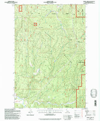
1995 Map of Merry Creek
USGS Topo · Published 1997About this map
The Middle Fork St Maries River and its numerous tributaries, including Merry Creek and Corbett Creek, carve through the complex topography of the Clearwater Mountains in this 1995 revision. The settlement of Clarkia sits near the southwestern corner, adjacent to a Sawmill and Gravel Pit, highlighting the area's ongoing connection to timber and resource extraction. Evidence of the region’s transportation history is preserved in the Old Railroad Grade Historical Trail and sections of Old RR Grade that wind through the St Joe National Forest. High-altitude points such as Swan Peak and passes like Hobo Pass and Davies Pass define the ridgelines, while The Incline suggests the steep engineering required for early industrial access. This map effectively documents the intersection of active forestry and historical infrastructure within the Clearwater National Forest.
Find a feature on this map
32 named features on this map. Tap any name to fly to it.
Don’t see what you’re looking for? This feature index may not catch every label — zoom into the map to look around manually.
Map Details
Editions of this 1995 Merry Creek Map
This is the sole edition of this map. No revisions or reprints were ever made.
Other maps of this area

1955 · Pullman
USGS Topo · 1:250,000

1955 · Spokane
USGS Topo · 1:250,000

1958 · Spokane
USGS Topo · 1:250,000

1958 · Pullman
USGS Topo · 1:250,000

1961 · Fernwood
USGS Topo · 1:62,500

1961 · Bovill
USGS Topo · 1:62,500

1969 · Marble Mountain
USGS Topo · 1:24,000

1969 · Anthony Peak
USGS Topo · 1:24,000

1969 · Grandmother Mtn
USGS Topo · 1:24,000
1969 · Grice Ridge
USGS Topo · 1:24,000