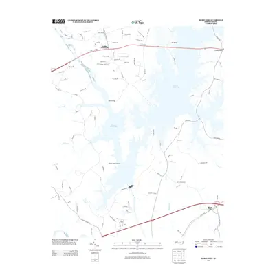
2013 Map of Merry Oaks
USGS Topo · Published 2013About this map
B Everett Jordan Lake dominates this portion of Chatham County, its intricate shoreline creating numerous inlets and peninsulas that reshaped the local geography. The massive Jordan Dam regulates the flow of the Haw River, which joins the Deep River near the southern boundary of the sheet. Settlements such as Merry Oaks, Wilsonville, and Seaforth are positioned around the reservoir, while Griffins Crossroads sits further inland. The landscape shows a mix of established rural communities and newer development like Crosswinds Estates Dr. Recreational infrastructure is evident at the Seaforth Rec Area, reflecting the area's transition toward a managed hydraulic and recreational landscape. Significant water features like Stinking Cr, Roberson Cr, and Weaver Cr provide a look at the natural drainage patterns that existed before and alongside the lake's inundation.
Find a feature on this map
111 named features on this map. Tap any name to fly to it.
Don’t see what you’re looking for? This feature index may not catch every label — zoom into the map to look around manually.
Map Details
Editions of this 2013 Merry Oaks Map
This is the sole edition of this map. No revisions or reprints were ever made.
Other maps of this area

1943 · Durham South
USGS Topo · 1:62,500

1951 · Farrington
USGS Topo · 1:24,000

1951 · Durham South
USGS Topo · 1:62,500

1953 · Raleigh
USGS Topo · 1:250,000

1954 · Raleigh
USGS Topo · 1:250,000

1968 · Bynum
USGS Topo · 1:24,000

1969 · New Hope Dam
USGS Topo · 1:24,000

1970 · Pittsboro
USGS Topo · 1:24,000

1970 · Colon
USGS Topo · 1:24,000

1970 · Moncure
USGS Topo · 1:24,000