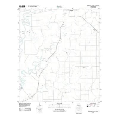
2010 Map of Merryville South
USGS Topo · Published 2010About this map
The Sabine River floodplain defines the western edge of this 2010 landscape, where the braided channels of the Old River and numerous oxbow features like Horseshoe Lake and Alligator Lake meet the sandy upland of Sabine Sands. This area, south of Merryville, reflects a region shaped by natural watercourses and the industrial footprint of petroleum extraction. The interior is marked by the Northwest Bivens Oil Field and Bivens Oil Field, connected by a network of rural roads such as Quave Rd and Rosalind Rd. Genealogists will find a high density of burial sites across this section of Beauregard Parish, including the Stark Cemetery, Inman Cemetery, and Meadow Cemetery. The presence of the Merryville Lookout Tower near the eastern boundary and the Old River-Hoosier Creek Dam to the south illustrates the infrastructure required for managing the vast timber and water resources of the Louisiana-Texas borderlands.
Find a feature on this map
44 named features on this map. Tap any name to fly to it.
Don’t see what you’re looking for? This feature index may not catch every label — zoom into the map to look around manually.
Map Details
Editions of this 2010 Merryville South Map
This is the sole edition of this map. No revisions or reprints were ever made.
Other maps of this area

1935 · Wilson Lake
USGS Topo · 1:31,680

1946 · Merryville
USGS Topo · 1:31,680

1947 · Singer
USGS Topo · 1:31,680

1947 · Pujo
USGS Topo · 1:31,680

1947 · Oretta
USGS Topo · 1:31,680

1947 · Wilson Lake
USGS Topo · 1:31,680

1947 · Hyatt
USGS Topo · 1:31,680

1947 · Bivens
USGS Topo · 1:31,680

1949 · Bancroft
USGS Topo · 1:31,680

1952 · Lake Charles
USGS Topo · 1:250,000