
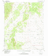
1956 Map of Mesa Aparejo
USGS Topo · Published 1958About this map
Mesa Lucero and Mesa Aparejo dominate this mid-century New Mexico landscape, where the high desert terrain is defined by complex arroyo systems and scattered cattle ranching operations. The area is characterized by a network of family-held properties and resting points, including Romero Ranch, Frost Ranch, and the aptly named Kings Rest. Water management is the primary human imprint on the land, evidenced by dozens of named tanks such as Shipping Tank, Esperanza Tank, and Llegua Tank that served the livestock industry across the Valencia and Socorro county line.
Find a feature on this map
56 named features on this map. Tap any name to fly to it.
Don’t see what you’re looking for? This feature index may not catch every label — zoom into the map to look around manually.
Map Details
Editions of this 1956 Mesa Aparejo Map
2 editions found
Other maps of this area

1916 · La Joya
USGS Topo · 1:125,000

1917 · Cerro Verde
USGS Topo · 1:125,000

1952 · La Joya NW
USGS Topo · 1:24,000

1952 · Belen SW
USGS Topo · 1:24,000

1952 · Belen NW
USGS Topo · 1:24,000

1952 · Rio Puerco
USGS Topo · 1:24,000

1954 · South Garcia SE
USGS Topo · 1:24,000

1954 · Socorro
USGS Topo · 1:250,000

1956 · South Garcia
USGS Topo · 1:62,500

1958 · Socorro
USGS Topo · 1:250,000