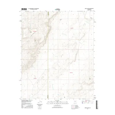
2017 Map of Mesa Gallina
USGS Topo · Published 2017About this map
Sierra Lucero and Mesa Gallina define this high-desert environment on the border of Valencia and Cibola counties. The topography is dominated by dramatic escarpments and dry watercourses that reflect the arid hydrology of the region. Distinctive landmarks like Mesa Aparejo and Cerro del Indio punctuate the landscape, while drainage systems such as Arroyo Salado and Arroyo Monte Largo carve through the basin. This survey shows the vital importance of man-made water catchments in the grazing lands of the American Southwest, specifically naming North Tank and Casey Tank. The presence of the Salt Flats in the southern portion of the quadrangle highlights the mineral-rich basins characteristic of this part of New Mexico, providing a clear picture of the land's geological character and its relationship to the shifting county boundary line.
Find a feature on this map
17 named features on this map. Tap any name to fly to it.
Don’t see what you’re looking for? This feature index may not catch every label — zoom into the map to look around manually.
Map Details
Editions of this 2017 Mesa Gallina Map
This is the sole edition of this map. No revisions or reprints were ever made.
Other maps of this area

1917 · Cerro Verde
USGS Topo · 1:125,000

1954 · South Garcia SE
USGS Topo · 1:24,000

1954 · Socorro
USGS Topo · 1:250,000

1956 · South Garcia
USGS Topo · 1:62,500

1956 · Mesa Aparejo
USGS Topo · 1:62,500

1958 · Socorro
USGS Topo · 1:250,000

1960 · Cerro Verde
USGS Topo · 1:24,000

1962 · Socorro
USGS Topo · 1:250,000
1964 · Chicken Mountain
USGS Topo · 1:24,000
1964 · Puerto De Los Cavadores
USGS Topo · 1:24,000