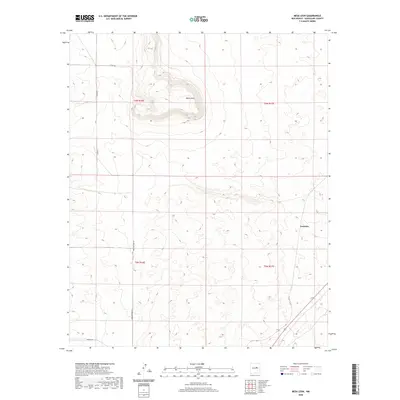
2020 Map of Mesa Leon
USGS Topo · Published 2020About this map
Mesa Leon rises as a prominent high-ground feature within this Guadalupe County landscape, defining the local topography between several township boundaries. The settlement of Leoncito is situated on the eastern edge of the quadrangle, where the terrain transitions toward more level ground. The area's connectivity is maintained through a network of local routes including Mesa de Leon Rd, Co Rd 4f, and Horace Rd, reflecting a rural ranching or grazing economy typical of this part of New Mexico. The cadastral layout is clearly marked by the intersections of t6n r16e, t6n r17e, t5n r16e, and t5n r17e, providing a precise framework for understanding land ownership and historical boundaries in the region.
Find a feature on this map
10 named features on this map. Tap any name to fly to it.
Don’t see what you’re looking for? This feature index may not catch every label — zoom into the map to look around manually.
Map Details
Editions of this 2020 Mesa Leon Map
This is the sole edition of this map. No revisions or reprints were ever made.
Other maps of this area

1954 · Fort Sumner
USGS Topo · 1:250,000

1958 · Fort Sumner
USGS Topo · 1:250,000
1978 · George Ranch
USGS Topo · 1:24,000

1978 · Mesa Leon
USGS Topo · 1:24,000
1978 · Tapia Ranch
USGS Topo · 1:24,000

1978 · Santa Barbara Lake
USGS Topo · 1:24,000

1978 · Vaughn
USGS Topo · 1:24,000

1978 · Tejon
USGS Topo · 1:24,000

1978 · Long Draw
USGS Topo · 1:24,000
1978 · Pinavete Canyon
USGS Topo · 1:24,000