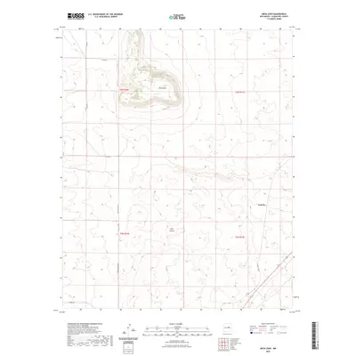
2023 Map of Mesa Leon
USGS Topo · Published 2023About this map
Mesa Leon dominates this high-plains landscape in Guadalupe County, where sharp elevation changes define the local geography. The map reveals a sparse network of ranch and county roads, including Mesa De Leon Rd and Horace Rd, which navigate around the significant topographic rise of the mesa and the neighboring Jesus Canyon. Settlement is extremely limited in this region of eastern New Mexico, with the small locale of Leoncito appearing as one of the few named points of interest. The Public Land Survey System lines for t6n r16e and surrounding townships overlay a terrain marked by scattered ephemeral water features and the rugged breaks of the mesa's edge. This 2023 survey illustrates a modern view of a largely unchanged rural environment where land use is dictated by the dramatic natural landforms.
Find a feature on this map
11 named features on this map. Tap any name to fly to it.
Don’t see what you’re looking for? This feature index may not catch every label — zoom into the map to look around manually.
Map Details
Editions of this 2023 Mesa Leon Map
This is the sole edition of this map. No revisions or reprints were ever made.
Other maps of this area

1954 · Fort Sumner
USGS Topo · 1:250,000

1958 · Fort Sumner
USGS Topo · 1:250,000
1978 · George Ranch
USGS Topo · 1:24,000

1978 · Mesa Leon
USGS Topo · 1:24,000
1978 · Tapia Ranch
USGS Topo · 1:24,000

1978 · Santa Barbara Lake
USGS Topo · 1:24,000

1978 · Vaughn
USGS Topo · 1:24,000

1978 · Tejon
USGS Topo · 1:24,000

1978 · Long Draw
USGS Topo · 1:24,000
1978 · Pinavete Canyon
USGS Topo · 1:24,000