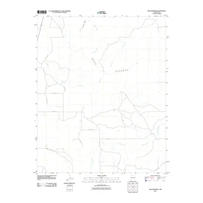
2010 Map of Mesa Redonda
USGS Topo · Published 2010About this map
Mesa Redonda dominates this portion of the New Mexico high plains, its distinctive landform providing a landmark for the surrounding network of rural roads and seasonal drainages. The small settlement of Garrett sits in the southwestern corner of the sheet, connected to the wider county by a grid of local routes such as Quay Road 44 and Quay Road AN. The landscape is defined by the complex system of arroyos and creeks that carve through the arid terrain, including the meandering paths of Barranca Creek, Paris Creek, and Rincon Creek. To the north, the terrain becomes more defined as Spikes Creek Canyon and Apodaca Creek cut toward the lower elevations. The map captures a quintessential ranching landscape in Quay County, where human presence is marked primarily by the sparse grid of numbered roads that navigate the varying elevations and dry creek beds.
Find a feature on this map
17 named features on this map. Tap any name to fly to it.
Don’t see what you’re looking for? This feature index may not catch every label — zoom into the map to look around manually.
Map Details
Editions of this 2010 Mesa Redonda Map
This is the sole edition of this map. No revisions or reprints were ever made.
Other maps of this area

1930 · Tucumcari
USGS Topo · 1:125,000

1954 · Tucumcari
USGS Topo · 1:250,000

1954 · Clovis
USGS Topo · 1:250,000

1958 · Clovis
USGS Topo · 1:250,000

1958 · Tucumcari
USGS Topo · 1:250,000

1968 · Bulldog Mesa
USGS Topo · 1:24,000
1968 · Briscoe Ranch
USGS Topo · 1:24,000
1968 · Tucumcari SE
USGS Topo · 1:24,000

1970 · Jordan
USGS Topo · 1:24,000

1970 · Quay
USGS Topo · 1:24,000