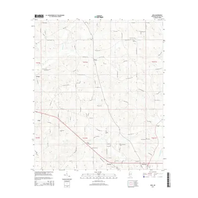
2015 Map of Mesa
USGS Topo · Published 2015About this map
Tylertown anchors the southeastern corner of this Walthall County landscape, where the local road network reflects generations of family settlement. Named rural crossroads like Mesa, Kioto, and Dinan dot the terrain, which is defined by the branching tributaries of Magees Creek and Leatherwood Cr. The map is particularly detailed for genealogical research, identifying numerous family-associated burial sites such as the Obed Magee Cem, Isaac Duncan Cem, and Elisha Thornhill Cem. These small cemeteries are often the last standing indicators of earlier community clusters. Infrastructure like the Paul Pittman Memorial Airport near Rushing shows the 21st-century evolution of the area, while the persistent grid of the Public Land Survey System continues to dictate property lines and the paths of roads like Bullock Rd and St Paul Rd.
Find a feature on this map
104 named features on this map. Tap any name to fly to it.
Don’t see what you’re looking for? This feature index may not catch every label — zoom into the map to look around manually.
Map Details
Editions of this 2015 Mesa Map
This is the sole edition of this map. No revisions or reprints were ever made.
Other maps of this area

1953 · Natchez
USGS Topo · 1:250,000

1956 · Natchez
USGS Topo · 1:250,000

1959 · Natchez
USGS Topo · 1:250,000
1970 · Tylertown SE
USGS Topo · 1:24,000

1970 · Kokomo
USGS Topo · 1:24,000

1970 · Mesa
USGS Topo · 1:24,000

1970 · Darbun
USGS Topo · 1:24,000

1970 · Jayess
USGS Topo · 1:24,000
1970 · Tylertown
USGS Topo · 1:24,000

1972 · Pricedale
USGS Topo · 1:24,000