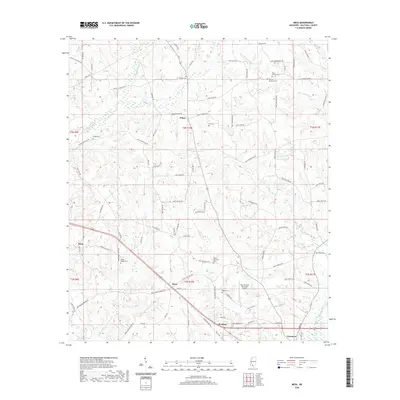
2020 Map of Mesa
USGS Topo · Published 2020About this map
Tylertown serves as a prominent landmark in the southeastern corner of this Walthall County landscape, where the terrain is defined by a dense network of creek systems including Leatherwood Cr and Magees Creek. The area around Dinan and Mesa reveals a long-established rural layout, with numerous family-named cemeteries such as Isaac Duncan Cem, Charlie Duncan Cem, and the Obed Magee Cem scattered across the countryside. These sites, along with the Elisha Thornhill Cem, provide significant touchpoints for genealogists tracing family roots in this part of Mississippi.
Find a feature on this map
98 named features on this map. Tap any name to fly to it.
Don’t see what you’re looking for? This feature index may not catch every label — zoom into the map to look around manually.
Map Details
Editions of this 2020 Mesa Map
This is the sole edition of this map. No revisions or reprints were ever made.
Other maps of this area

1953 · Natchez
USGS Topo · 1:250,000

1956 · Natchez
USGS Topo · 1:250,000

1959 · Natchez
USGS Topo · 1:250,000
1970 · Tylertown SE
USGS Topo · 1:24,000

1970 · Kokomo
USGS Topo · 1:24,000

1970 · Mesa
USGS Topo · 1:24,000

1970 · Darbun
USGS Topo · 1:24,000

1970 · Jayess
USGS Topo · 1:24,000
1970 · Tylertown
USGS Topo · 1:24,000

1972 · Pricedale
USGS Topo · 1:24,000