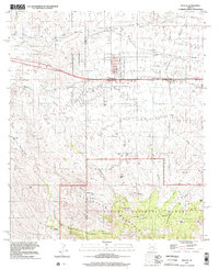
1996 Map of Mescal
USGS Topo · Published 2002About this map
The high desert landscape of Whetstone Mountains and the Coronado National Forest dominates the southern reaches of this 1996 survey. This rugged terrain is defined by a network of drainage systems, including Anderson Canyon, Wakefield Canyon, and Cherry Canyon, which carve through the foothills of peaks like Haystack Mtn and Easter Mtn. The area's ranching heritage is clearly marked by family-named properties and water sources such as the Double X Ranch, Jay Six Ranch, and Williams Ranch, along with critical water points like Wildcat Well and Bill Williams Tank.
Find a feature on this map
32 named features on this map. Tap any name to fly to it.
Don’t see what you’re looking for? This feature index may not catch every label — zoom into the map to look around manually.
Map Details
Editions of this 1996 Mescal Map
This is the sole edition of this map. No revisions or reprints were ever made.
Other maps of this area

1904 · Patagonia
USGS Topo · 1:125,000

1904 · Tucson
USGS Topo · 1:125,000

1905 · Patagonia
USGS Topo · 1:125,000

1905 · Tucson
USGS Topo · 1:125,000

1915 · Benson
USGS Topo · 1:125,000

1926 · Whetstone
USGS Topo · 1:62,500

1943 · Benson
USGS Topo · 1:125,000

1945 · Happy Valley
USGS Topo · 1:62,500

1956 · Nogales
USGS Topo · 1:250,000

1956 · Tucson
USGS Topo · 1:250,000