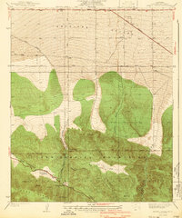
1940 Map of Mescal Creek
USGS Topo · Published 1940About this map
Antelope Valley meets the northern slopes of the San Gabriel Mountains in this early 1940s study of the high desert transition. The landscape is defined by the massive tectonic scarring of the San Andreas Rift Zone, which runs northwest-southeast across the lower third of the quadrangle. Small-scale settlement and ranching are concentrated around the foothills, with Largo Vista serving as a notable point of interest alongside the Soules Ranch further south.
Find a feature on this map
26 named features on this map. Tap any name to fly to it.
Don’t see what you’re looking for? This feature index may not catch every label — zoom into the map to look around manually.
Map Details
Editions of this 1940 Mescal Creek Map
3 editions found
Other maps of this area

1901 · Southern California Sheet No. 1
USGS Topo · 1:250,000

1903 · Rock Creek
USGS Topo · 1:62,500

1903 · San Antonio
USGS Topo · 1:62,500

1904 · Southern California Sheet No. 1
USGS Topo · 1:250,000

1930 · Black Butte
USGS Topo · 1:24,000

1930 · Llano
USGS Topo · 1:24,000

1930 · Angle
USGS Topo · 1:24,000

1932 · Angle
USGS Topo · 1:24,000

1933 · Black Butte
USGS Topo · 1:24,000

1934 · Mescal Creek
USGS Topo · 1:24,000